
It is smaller than a nickel, moves at a snail’s pace and can easily go…
What’s Going On With This Weird Montana Winter?
This winter has felt very different from what Montanans typically expect. Temperatures have been unusually warm, snowfall has been limited, and many of us have seen sights that would normally be unthinkable in January or February. I have friends who have been sunbathing outdoors, and it hasn’t been uncommon to see people walking around in shorts, sandals, and short sleeves — at a time of year when we usually worry about frostbite on exposed skin.
Data supports what many of us have been noticing. An analysis of National Weather Service records by Montana Free Press shows that five of Montana’s seven largest cities recorded daily high temperatures this fall and early winter more than eight degrees above normal on average, with records for individual days continuing to be set into early February.
In Billings, Bozeman, Great Falls, Helena, and Missoula, the average daily high temperatures from November through January were warmer than any previous winter on record dating back to the mid-20th century. Butte and Kalispell, where weather records extend back more than a century, also came close to setting new records.
Bozeman has seen one of the most dramatic departures from normal. The average daily high temperature from November through January was 45 degrees — about 10 degrees above the historic average and 3.5 degrees warmer than the previous warmest winter since records began in 1941. Notably, three of Bozeman’s warmest winters have occurred within the past five years.
Why Is This Happening?
Large-scale climate patterns in the Pacific Ocean help shape winter weather across North America. Under normal conditions, trade winds push warm surface water west toward Asia while colder water rises near South America in a process known as upwelling.
Two climate patterns — El Niño and La Niña — disrupt these normal conditions. These cycles typically occur every two to seven years and can last from several months to multiple years. Both patterns influence weather, ecosystems, agriculture, and wildfire conditions worldwide.
During El Niño events, trade winds weaken and warm ocean water shifts east toward the Americas. This often pushes the Pacific jet stream south, leading to warmer and drier conditions across the northern United States, including Montana.
La Niña produces the opposite pattern. Stronger trade winds push warm water toward Asia while colder water rises along the west coast of the Americas. This often shifts the jet stream northward, bringing wetter conditions to the Pacific Northwest and sometimes colder conditions to the northern United States.
These shifting climate patterns are one reason Montana winters can vary significantly from year to year.
Effects on Trees and Landscapes
One unusual feature of this winter has been the early signs of plant growth. Lawns are still green in some areas, and trees and shrubs have begun to show signs of budding weeks earlier than normal. Warm spells can confuse plants that rely on temperature cues to regulate their growth cycles.
If freezing temperatures return after plants begin growing, some damage is likely — particularly to early-blooming trees and shrubs. Spring-flowering plants are especially vulnerable because freezing temperatures can damage or destroy blossoms.
Newly emerged leaves may also be damaged by freezing weather. Fortunately, most established trees and shrubs are resilient and can produce a second flush of leaves if early growth is lost. Healthy plants usually recover within a few weeks, especially if they receive adequate water during the growing season. Younger trees and shrubs planted within the past three to five years may benefit from extra care if damage occurs.
Fruit Trees and Spring Freezes
Freezing temperatures generally do not harm plants while they are dormant. However, once buds begin to swell and flowers develop, plants become increasingly vulnerable to cold temperatures.
Fruit trees that bloom early, such as apricots and peaches, are especially susceptible to spring freezes. Apples, pears, and cherries typically bloom later and are somewhat less vulnerable.
Even modest drops in temperature can affect fruit production. At full bloom, temperatures of about 28 degrees Fahrenheit may destroy roughly 10 percent of apple blossoms, while temperatures near 25 degrees may destroy as much as 90 percent. While a late freeze can significantly reduce the fruit crop for the year, the trees themselves are unlikely to suffer permanent damage.
Effects on Perennials
Warm weather may also encourage early growth in perennials such as hosta, columbine, and bleeding heart. Freezing temperatures can damage this early foliage, but the roots and crowns usually remain unharmed. Most perennials will produce new growth within a few weeks, particularly if they receive good care during the spring and summer.
Evergreen Winter Stress
Warm, dry winters with little snow cover can also stress evergreen trees and shrubs. Unlike deciduous plants, evergreens continue to lose moisture through their needles and leaves during winter. When the ground is frozen and humidity is low, evergreens can lose more moisture than they are able to replace.
This condition, often called winter burn or desiccation, causes needles or leaves to turn brown, especially on the south and southwest sides of plants where exposure to sun and wind is greatest.
During extended warm periods with little snow cover, evergreens may benefit from occasional watering. When temperatures rise above 40 degrees, watering around the outer edge of the branches — known as the drip line — can help replenish moisture in the root zone. Water should be applied slowly to allow it to soak into the soil where it is most needed.
Looking Ahead
Montana weather has always been unpredictable, but this winter stands out for its unusual warmth and lack of snow. While many Montanans have enjoyed the mild temperatures, snowpack remains one of the most important factors shaping our water supply each year. Snowpack acts as Montana’s natural reservoir, slowly releasing water into streams and irrigation systems throughout the spring and summer.
So what does this winter mean for our water outlook?
According to data from the Gallatin Valley’s three SNOTEL monitoring stations, snowpack is currently slightly below normal following a warm and relatively dry January. Most river basins are sitting at roughly 65 to 90 percent of normal snowpack, with some areas closer to 75 to 85 percent of median snow water equivalent.
Higher elevations are holding snow reasonably well, but mid-elevation snowpack is lagging behind normal levels, and lower elevations have experienced reduced snow cover or periods of bare ground. This pattern is typical of warm winters, when more precipitation falls as rain instead of snow.
At this point, conditions are not alarmingly low, but they are worth watching closely. March and April are often the most important months for snow accumulation in southwest Montana, and a few strong storms could still improve the outlook.
Ultimately, we still have a significant portion of winter ahead, and it is too early to predict exactly what the water supply will look like this year. Montana depends heavily on late-winter snowpack, and storms in March and April often determine the outcome. The next several weeks will play an important role in shaping our streams, landscapes, and water supplies for the year ahead.
Becky Clements
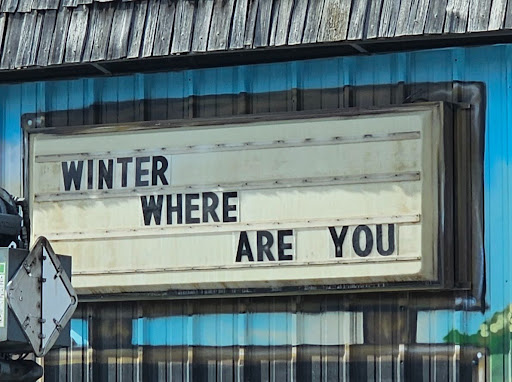
“WINTER WHERE ARE YOU” Featured at Shedhorn Sports in Ennis, Montana
